











08:30至下午05:30 地址:臺北市中正區100006公園路64號 總機:(02)2349-1000(代表號) 氣象查詢:(02)2349-1234 地震查詢:(02)2349-1168
本網站參考時間:臺灣標準時間TST(GMT +08:00)
地震參數下載
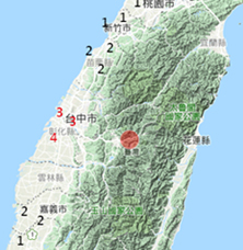
第116號 6月17日5時10分 規模 3.1 花蓮縣政府南偏西方 31.7 公里 (位於花蓮縣鳳林鎮)
Origin Time:2012/06/17 05:10:50
Lon:121.48°E
Lat:23.74°N
Depth:9.2km
Mag:3.1
Stacode=EGF ,Staname=光復 ,Stalon=121.48,Stalat=23.68,Dist= 5.70,AZ=355.73,PGA(V)= 8.79,PGA(NS)= 19.08,PGA(EW)= 11.90
Stacode=EGC ,Staname=磯崎 ,Stalon=121.55,Stalat=23.71,Dist= 7.71,AZ=293.76,PGA(V)= 3.35,PGA(NS)= 3.89,PGA(EW)= 4.13
Stacode=ESL ,Staname=西林 ,Stalon=121.44,Stalat=23.81,Dist= 9.21,AZ=155.95,PGA(V)= 3.47,PGA(NS)= 9.93,PGA(EW)= 13.10
Stacode=ESF ,Staname=壽豐 ,Stalon=121.51,Stalat=23.87,Dist= 15.23,AZ=191.18,PGA(V)= 0.90,PGA(NS)= 2.33,PGA(EW)= 1.62
Stacode=EHY ,Staname=紅葉 ,Stalon=121.33,Stalat=23.50,Dist= 29.93,AZ= 30.83,PGA(V)= 0.42,PGA(NS)= 1.02,PGA(EW)= 1.26
詳細資料
